 Fireblaze
 Aerospace & Defence AI
IBM–NASA Prithvi: The Open Foundation Model Transforming Earth Observation
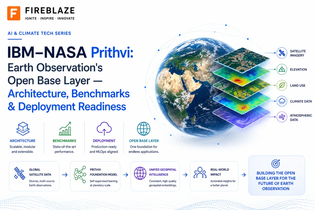
IBM–NASA Prithvi: Earth Observation's Open Base Layer: Architecture, Benchmarks & Deployment Readiness
The Open Geospatial Foundation Model Trying to Become Earth Observation's Base Layer
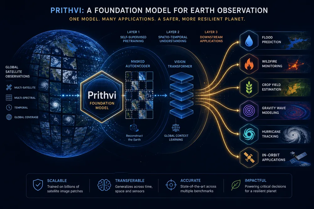
Executive Summary
Prithvi is a family of open-source geospatial foundation models jointly developed by IBM Research and NASA, with contributions from the Jülich Supercomputing Centre, Oak Ridge National Laboratory, and a broader academic and agency consortium. It is the most concretely documented and independently verifiable example of the "foundation model for Earth Observation" category: model weights are open on Hugging Face under an Apache 2.0 license, architecture and pretraining are described in a peer-reviewed paper, benchmark results come from a standardized third-party framework (GEO-Bench), and: as of 2026: a compressed version of the model is running aboard two orbital platforms.
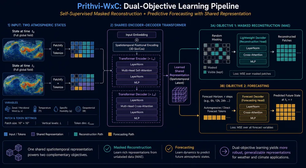
The Prithvi family splits into two product lines. Prithvi-EO is a temporal Vision Transformer pretrained on NASA's Harmonized Landsat Sentinel-2 (HLS) imagery, released across 100M/300M/600M parameter tiers plus lightweight edge variants. Prithvi-WxC is a separate 2.3-billion-parameter encoder-decoder transformer pretrained on 40 years of MERRA-2 atmospheric reanalysis data, targeting weather and climate applications rather than surface imagery.
Key findings:
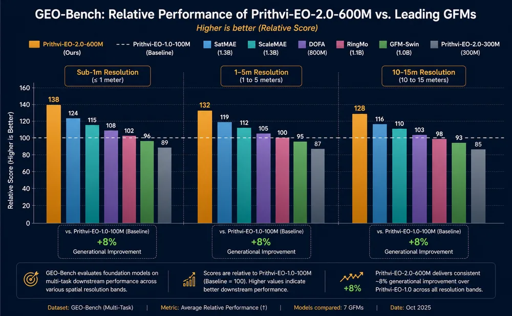
- Prithvi-EO-2.0-600M outperforms its predecessor by 8% on the GEO-Bench evaluation framework and outperforms six competing geospatial foundation models on tasks spanning 0.1m–15m resolution, despite a native pretraining resolution of 30m.
- IBM and NASA have released named, production-oriented fine-tuned models for flood mapping, wildfire burn-scar segmentation, and multi-temporal crop classification, demonstrating the "pretrain once, fine-tune cheaply many times" economics the foundation-model approach is built on.
- Prithvi-WxC has been fine-tuned for gravity-wave parameterization, climate/weather downscaling, hurricane-track identification, and is under evaluation for localized renewable-energy forecasting; it reconstructed global surface temperature fields from only 5% of input data in one internal demonstration.
- In 2026, a compressed Prithvi-EO model became the first geospatial foundation model to run in orbit, deployed aboard the Kanyini satellite and the ISS-mounted IMAGIN-e payload: a concrete signal of production maturity, not a research claim.
- Material limitations remain: a 30-meter native resolution ceiling that limits sub-meter application, task- and dataset-dependent transfer performance, and an active competitive field (Google DeepMind's AlphaEarth Foundations, the open Clay model) that means Prithvi should be read as the leading documented candidate for an Earth Observation base layer, not a settled winner.
1. Introduction and Purpose
Geospatial foundation models (GFMs) apply the "pretrain once on unlabeled data, fine-tune cheaply for many downstream tasks" paradigm: first proven at scale by large language models: to satellite and atmospheric data. Instead of building a bespoke model from scratch for every remote-sensing problem (flood detection, crop classification, burn-scar mapping), a single large model is pretrained via self-supervision on massive volumes of unlabeled imagery, and lightweight task-specific heads are fine-tuned on top of it using comparatively small labeled datasets.
Several organizations are pursuing this category with structurally different bets: a fine-tunable open-weights backbone, a precomputed-embedding product, and open community alternatives. Prithvi is the clearest and most thoroughly documented example of the first approach, and this report treats it as a named case study: evaluating what the architecture actually does mechanically, what has been benchmarked and released, and where the honest limitations sit: rather than as a general market survey.
2. Origins and Release Timeline
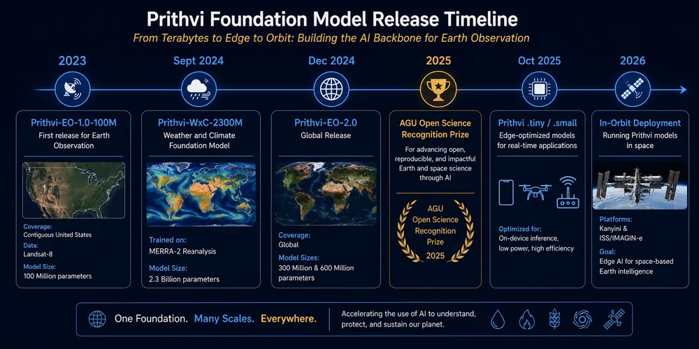
Prithvi's first release, Prithvi-EO-1.0-100M, shipped in 2023 as a temporal Vision Transformer pretrained on contiguous-US Harmonized Landsat Sentinel-2 (HLS) data: notable at the time for handling a genuine time series of remote-sensing images rather than a single static frame. Prithvi-EO-2.0 followed in December 2024, expanding the pretraining footprint from the contiguous US to a global scale, scaling model capacity to 300M and 600M parameters, and adding explicit geolocation and temporal metadata encoding. The model subsequently received the American Geophysical Union's 2025 Open Science Recognition Prize.
In September 2024, the family branched into a second product line with Prithvi-WxC, a 2.3-billion-parameter weather and climate foundation model trained on NASA's MERRA-2 atmospheric reanalysis rather than satellite imagery: signaling that "Prithvi" was being positioned as a family of foundation models spanning Earth-system data types. In October 2025, IBM open-sourced lightweight .tiny and .small variants of both Prithvi and its sibling model TerraMind, designed to run on edge devices and conventional laptops.
3. Architecture
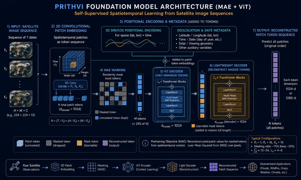
Prithvi-EO-2.0 is a masked autoencoder (MAE) built on a Vision Transformer (ViT) backbone, with two deliberate modifications made to handle spatiotemporal Earth-observation data.
3.1 Base Structure
As in any MAE, each input image is divided into non-overlapping patches, embedded via linear projection, and a large subset of patches is randomly masked. Only unmasked patches are processed by the (larger, more expensive) encoder's Transformer blocks; a lightweight decoder reconstructs the full image from the encoder's output plus learned placeholder tokens for the masked positions. This asymmetry keeps large-scale pretraining computationally tractable, since the expensive encoder only processes a fraction of the actual input.
3.2 Modification 1: 3D Patch and Positional Embeddings
Standard MAE architectures use 2D patch embeddings suited to a single static image. Prithvi replaces these with 3D patch embeddings: a 3D convolutional layer dividing a sequence of T images of size (H, W) into non-overlapping cubes of size (t, h, w) across time, height, and width. Because satellite revisit intervals are irregular and comparatively sparse, the temporal cube dimension is set to t=1, with each acquisition date treated as its own slice inside a shared 3D positional scheme: 1D sin/cos encodings generated separately per dimension and combined into a single 3D positional encoding.
3.3 Modification 2: Geolocation and Date Metadata
Beyond patch-level position, Prithvi-EO-2.0 feeds the model sample-level geographic and temporal context: center latitude/longitude and year/day-of-year: via 2D sin/cos embeddings provided independently to both encoder and decoder. This lets the model condition its representation on where and when an observation was taken, which matters because identical spectral signatures can carry different meaning across biomes and seasons.
3.4 Output Configuration
The default configuration handles T=4 timesteps at 224×224 spatial extent with a patch size of (1, 16, 16). Output is a sequence of patch tokens at 1024 dimensions (300M-parameter variant) or 1280 dimensions (600M-parameter variant): the representation every downstream fine-tuning task builds on.
3.5 Pretraining Data
Prithvi-EO's pretraining corpus is NASA's Harmonized Landsat Sentinel-2 (HLS) product: a calibrated, cross-sensor-consistent dataset at 30-meter resolution using six spectral bands (Blue, Green, Red, Near-Infrared, and two Shortwave-Infrared bands). Prithvi-EO-1.0 was pretrained on a contiguous-US footprint; Prithvi-EO-2.0's global expansion sampled across hundreds of distinct ecoregions to generalize beyond the original US-only scope. This 30-meter, six-band training regime is the specific factor behind both Prithvi's strengths and its principal limitation (Section 9).
4. Released Model Family
| Model | Parameters | Data / Domain | Distinguishing Feature |
|---|---|---|---|
| Prithvi-EO-1.0-100M | 100M | Contiguous US, HLS 6-band | First release; established temporal ViT + MAE pattern |
| Prithvi-EO-2.0-300M | 300M | Global, HLS 6-band | Global pretraining footprint; base 2.0 generation |
| Prithvi-EO-2.0-600M | 600M | Global, HLS 6-band | Largest capacity variant; best GEO-Bench performance |
| Prithvi-EO-2.0-300M/600M-TL | 300M / 600M | Global, HLS 6-band | "TL" = explicit geolocation + temporal metadata in pretraining |
| Prithvi-EO .tiny / .small | Reduced | Global, HLS 6-band | Released Oct 2025 for edge devices and laptop fine-tuning |
| Prithvi-WxC-2300M | 2.3B | Global, MERRA-2 (160 variables) | Separate line: weather/climate reanalysis (Section 7) |
All variants are released under an Apache 2.0 license on the IBM-NASA (and, for the newest edge models, IBM-ESA) Hugging Face organizations, with fine-tuning supported through IBM's open-source TerraTorch toolkit. This licensing and tooling model is a direct point of differentiation from precomputed-embedding competitors, which trade fine-tuning flexibility for eliminating the GPU-inference step entirely.
5. Downstream Fine-Tuning and Applications
Alongside the initial open-source release, IBM and NASA shipped named, fine-tuned task models built on the Prithvi-EO backbone, rather than leaving fine-tuning purely as an exercise for end users.
| Application | Basis / Dataset | Status |
|---|---|---|
| Flood mapping | sen1floods11 flood-labeled dataset | Released alongside initial open-source launch |
| Burn-scar identification | Four-class wildfire burn-intensity segmentation | Released alongside initial open-source launch |
| Multi-temporal crop classification | Growing-season image time series | Released alongside initial open-source launch |
| Above-ground biomass estimation | BioMassters-style multimodal Sentinel-1/2 data | GEO-Bench evaluation task |
| Agricultural yield / land-use mapping | County-level yield, cover-crop, tillage classification | Reported in practitioner literature |
These releases test the "base layer" claim against concrete deliverables rather than leaving it as an architectural description: each named model required comparatively small labeled datasets because the general-purpose representation was already learned during pretraining.
6. Benchmark Performance
Prithvi-EO-2.0's central, third-party-comparable claim rests on GEO-Bench, a standardized multi-sensor, multi-resolution evaluation framework for geospatial foundation models.
- Prithvi-EO-2.0-600M outperforms Prithvi-EO-1.0 by 8% across a range of tasks.
- Prithvi-EO-2.0-600M outperforms six other geospatial foundation models on tasks spanning 0.1m–15m resolution: a wide span relative to its own 30-meter native pretraining resolution, indicating genuine transfer outside its training regime.
- On burn-intensity segmentation specifically, Prithvi-EO-2.0-300M was found comparable to a standard U-Net baseline on mean IoU and mean F1 score: a modest, honestly-reported difference rather than a decisive win.
7. Prithvi-WxC: Weather and Climate Line
Prithvi-WxC is a materially different product from Prithvi-EO in scale, data, and architecture.
7.1 Scale and Training Data
Prithvi-WxC is a 2.3-billion-parameter model pretrained on 160 atmospheric variables from NASA's MERRA-2 reanalysis dataset, spanning 40 years (1980–present) at 0.625° spatial resolution and 3-hourly temporal resolution.
7.2 Architecture and Training Objective
Unlike Prithvi-EO's MAE-ViT structure, Prithvi-WxC uses an encoder-decoder transformer built to capture both regional and global dependencies while managing long token sequences, supporting the incorporation of additional off-grid observation tokens during fine-tuning. The initial release (prithvi.wxc.2300m.v1) was pretrained with a 50% masking ratio on a dual objective: masked reconstruction and forecasting simultaneously. The model takes atmospheric state from two input timestamps and learns to generate a third: either filling gaps in the observed window or propagating state forward in time.
In one internal demonstration, this reconstruction capability accurately rebuilt global surface temperature fields from a random sample of only 5% of the original data, a result flagged as suggestive of broader application to data assimilation.
7.3 Named Fine-Tuned Applications
| Application | Description |
|---|---|
| Gravity wave parameterization | Helps climate models account for sub-grid-scale gravity wave effects; released alongside the WxC base model |
| Climate/weather downscaling | Infers higher-resolution detail from coarser model output; released as part of the IBM Granite model family |
| Hurricane track identification | Demonstrated zero-shot prediction of Category 4 Hurricane Ida's (2021) track |
| Localized renewable energy forecasting | Named as an application area under active evaluation |
8. Deployment Status: In-Orbit Operation
The clearest signal that Prithvi has moved from research artifact to deployed infrastructure is physical: in 2026, a team from Adelaide University, ESA's Φ-lab, Thales Alenia Space, and the SmartSat Cooperative Research Centre compressed and uploaded a version of Prithvi-EO to run aboard two orbital platforms: South Australia's Kanyini satellite, and the Thales Alenia Space IMAGIN-e payload mounted on the International Space Station. This made Prithvi the first geospatial foundation model deployed in orbit, tested directly for flood and cloud-detection performance on the spacecraft rather than on downlinked imagery.
The strategic significance is bandwidth, not novelty alone: on-board inference lets a satellite transmit a compact, already-processed output (a flood mask, a cloud flag) instead of raw imagery requiring ground-based processing: directly enabling faster disaster response with substantially less bandwidth consumed. The October 2025 .tiny/.small edge releases were the direct infrastructural precondition for this milestone.
9. Limitations and Risk Factors
9.1 Resolution Ceiling
Prithvi-EO is pretrained at 30-meter resolution on six HLS spectral bands. While GEO-Bench shows useful transfer down to 0.1-meter tasks, sub-meter perception tasks: weed segmentation, fruit counting, disease-lesion detection from in-cab or drone cameras: fall outside what a 30-meter-native pretraining corpus can meaningfully support.
9.2 Task- and Dataset-Dependent Transfer
A 2024 evaluation of Prithvi's domain adaptability found that input-resolution effects on downstream performance varied by dataset characteristics rather than following one consistent rule. "Fine-tune Prithvi" is not a universally safe default: variant, resolution, and fine-tuning data requirements need empirical validation per task.
9.3 Competitive Position, Not a Settled Outcome
Prithvi competes with structurally different approaches, including Google DeepMind's precomputed-embedding AlphaEarth Foundations and the open community model Clay. Prithvi should be read as the most concretely documented and operationally advanced candidate for an Earth Observation base layer: the strongest paper trail: not as a settled winner in a still-open field.
10. Strategic Implications for Defense and Aerospace Applications
- Bandwidth-constrained operations: the orbital deployment (Section 8) is a direct template for missions where downlink bandwidth is the binding constraint, since a compressed Prithvi-EO backbone can produce compact outputs without transmitting raw imagery.
- Vendor independence: open licensing means adoption is not dependent on a single commercial vendor's roadmap or pricing.
- Sparse-sensor data assimilation: Prithvi-WxC's demonstrated reconstruction from 5% of input data is directly relevant to compute-constrained, edge-deployed assimilation for forward-deployed units with limited sensor suites.
- Required due diligence: fine-tuned performance must be validated against the actual geography, sensor characteristics, and resolution regime relevant to a given mission; sub-meter tasks sit outside what either backbone can handle without a fundamentally different, higher-resolution data source.
11. Glossary
| Term | Definition |
|---|---|
| Prithvi-EO | Earth Observation imagery line: temporal Vision Transformer pretrained via masked autoencoding on HLS satellite imagery |
| Prithvi-WxC | Weather and Climate line: separate 2.3B-parameter encoder-decoder transformer pretrained on MERRA-2 reanalysis |
| HLS | NASA's calibrated, cross-sensor-consistent 30m satellite imagery product combining Landsat and Sentinel-2 |
| MERRA-2 | NASA's 40-year global atmospheric reanalysis dataset used to pretrain Prithvi-WxC |
| 3D patch/positional embedding | Prithvi-EO's core modification: 3D (time, height, width) embeddings replacing standard 2D MAE embeddings |
| GEO-Bench | Standardized multi-sensor, multi-resolution benchmark for comparing geospatial foundation models |
| TerraTorch | IBM's open-source toolkit for fine-tuning Prithvi and related geospatial foundation models |
| On-orbit inference | Running model inference aboard a satellite rather than downlinking raw imagery for ground processing |
12. Sources
Prithvi-EO-2.0 technical paper (Szwarcman, Jakubik, Roy, et al.) · NASA-IMPACT and IBM-NASA-geospatial GitHub/Hugging Face model cards · IBM Research's Oct 2025 .tiny/.small announcement · NASA Earthdata's Prithvi-WxC background article · IBM Research AGU 2024 publication · NASA SC24 project summary (Hurricane Ida demo) · 2025 gravity-wave parameterization case study · 2024 arXiv domain-adaptability evaluation · 2026 agricultural ML practitioner survey · NASA Science coverage of the 2026 in-orbit deployment.
Keep Reading
Related Articles
Aerospace & Defence AI
How GPS/GNSS Spoofing and Jamming Actually Work: A Practical Primer
GPS and other GNSS systems rely on extremely weak satellite signals, making them vulnerable to jamming and spoofing attacks. This practical primer exp
Kinetic vs. Directed Energy: Inside the AI Deciding How to Defeat a Drone Swarm
Once a hostile drone is confirmed, someone: or something: has to decide how to stop it. This article compares kinetic interceptors, high-energy lasers
The Open Datasets Quietly Powering the Next Generation of Space Defence AI
Most defense AI progress is bottlenecked by one thing: classified data. This piece looks at how open datasets like SPLID: built by MIT with 2,402 labe